GIS & Mapping


GIS & Mapping
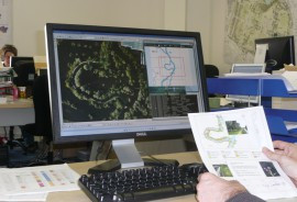
The scope for Geographic Information System (GIS) as a surveying tool for ecological planning is huge. GIS are used to provide interactive mapping and to analyse survey data. The more sophisticated surveying techniques, such as the National Vegetation Classification (NVC), which identifies and categorises specific vegetation communities on the basis of their detailed plant composition, depend on GIS mapping.
GIS mapping helps our understanding of the ecology of a site, such as what needs to be conserved and the potential for enhancement. It allows clients to effectively manage their wildlife conservation. The Ecology Consultancy’s in-house team are experts in this regard and use a variety of software including ArcGIS, Map Info and AutoCAD. Accurate and informative mapping is a key aspect of our reporting.
Our GIS mapping team provides clients with a valuable tool for effectively managing their wildlife conservation planning.
GIS Capabilities
All ecology features are stored in customised geospatial datasets and associated within our GIS environment. We take a systematic and standardised approach to ensure accurate geo-referencing of maps and other remote sensing data.
Our GIS team is experienced in data capture and geo-processing of field survey data, and we use special in-house applications to provide interactive mapping. Our GIS capabilities integrate a powerful set of GIS/CAD software with automated tools (ESRI ArcGIS, XTools, and AutoCAD) that assist in streamlining processes and continually improve the overall output quality.
We have expertise in GIS analysis, relational database design, spatial analysis, thematic cartography for Environmental Impact Assessments.
All ecology maps, from local studies to regional analysis, are presented to scale and linked with a geographic location.
Our GIS output includes thematic maps for habitat plans, protected species surveys, and BREEAM assessments in different paper sizes, and with final layouts in PDF, CAD or SHP format.
- Region: Europe
- Country: United Kingdom
- {{ error }}
- Request sent successfully.